Category: Greek Islands photos (page 9 of 70)

Quietly spectacular Skyros

Share

Enjoy aerial views of the island’s wonderful coastal, mountain, valley and village scenery in the film Skyros 2018 by Skylens (above),  in Skyros – Cinematic Travel Video in 4K by Andre Eckhardt Films (center), and in Skyros – Greece by TreeZone (below) 


~ Editor’s note: This article was updated on September 27 2018 with the addition of the Skyros 2018 video, and on October 2 2019 with the addition of the Skyros Cinematic Travel Video posted above ~


Real deal: Want to visit an authentic Greek island that isn’t a mainstream tourist magnet like Mykonos, Rhodes, Santorini, or even its nearby neighbour, Skiathos? Then have a look at Skyros, the southernmost and largest island in the Sporades archipelago. Skyros has everything you would want and expect from a great Greek island holiday destination — impressive landscapes and coastal scenery, inviting beaches, picturesque villages, historic sites, good food, and age-old local traditions — without the massive crowds and commerciality of other islands that have become household names around the world.

Though it is becoming increasingly popular with visitors from around the world, and has an international airport that receives direct charter flights from several European cities during July and August, Skyros is a relatively low-profile destination that isn’t even on the radar for most tourists planning vacations in the Greek islands.

In fact, there were only 3 question-and-answer threads posted on TripAdvisor’s Skyros travel forum in all of 2015, and just 10 in total since 2010. The Skiathos forum, by comparison, had  more than 6,100 conversation threads as of mid-May 2016.


With so much going for the island, It’s rather surprising that Skyros doesn’t get more attention from travellers — especially considering that it gets good press whenever it’s mentioned in social and regular media.

For instance, Skyros was cited as the best destination for alternative travel and holistic holidays in The Telegraph’s January 2016 feature The 19 best Greek islands, and was included in a piece the Independent published about Holidays for single travellers. Also in January, The Irish Examiner published A letter from paradise on the Greek island of Skyros, a journalist’s account of her writing holiday. And in 2015, Thomas Cook Airlines named Skyros as best destination for “healthy lifestyle holidays” in its profile of Greece’s top 10 islands.

Perhaps it’s a good thing Skyros hasn’t become hugely popular — that means it will remain a unique and special place to charm and delight those travellers who do venture off the main tourist paths to pay it a visit. (And that’s one of the chief reasons why Skyros is on my bucket list of islands to see.)

Skyros photo from sail-la-vie.com

Built on the steep slopes of a craggy peak topped by a Byzantine fortress and a  monastery, Chora village is a striking sight on Skyros (Photo from the Municipality of Skyros travel guide)


Please continue reading on page 2, where you’ll find more pictures and videos along with links to more than a dozen different websites with Skyros travel information and photos.

CONTINUED ON PAGE 2

Pages: 1 2

The bewitching but dangerous beauty of Santorini’s Red Beach

Share

Red Beach Santorini

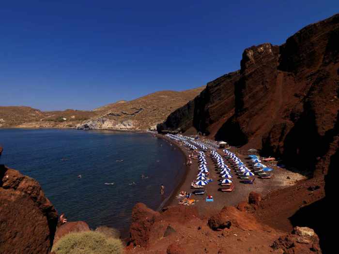
Santorini’s Red Beach is seen in an image from EscapeGreece.com 


[Editor’s Update: If you plan to visit Santorini in 2018, please beware that Red Beach is officially closed to the public. Click here to read about a landslide that occurred on Red Beach in April 2018 and led island authorities to re-issue warnings that the beach is off limits because it’s too dangerous to visit.] 


Rockfall risk: Since Santorini enjoys a worldwide reputation for superlative natural scenery, it’s not surprising that the island’s remarkable Red Beach regularly garners glowing accolades from international travel publications and leading lifestyle websites — along with ample attention on social media, where thousands of people have posted selfies that they shot on and near the colourful coastal attraction.

During my routine online work and research, I frequently find articles in which travel magazines and websites declare Red Beach to be one of the world’s “best,” “most beautiful,” “most unusual” or “most colourful” beaches, and recommend it as a “must-see” for anyone visiting Santorini.  Photos of the distinctive strand, which is also known as Red Sand Beach, appear even more often on websites and social media pages dedicated to travel in Greece, and in particular for hotels and tour companies operating on Santorini.


What the articles, posts and photo captions rarely mention, however, is that Red Beach is a veritably perilous place to sunbathe, swim or stroll. In recent years, there have been several significant rockfalls and landslides from the crimson-coloured bluffs that rise behind the narrow strip of scarlet-tinged pebbles and stones, and geological experts believe it’s possible that more cliff sections could collapse onto the beach at any time. (There are anecdotal claims that two beachgoers were killed by a landslide a few years ago, but I couldn’t find any news reports confirming the fatalities or date of the accident.)


Red Beach Santorini photo by TripAdvisor member Chris B

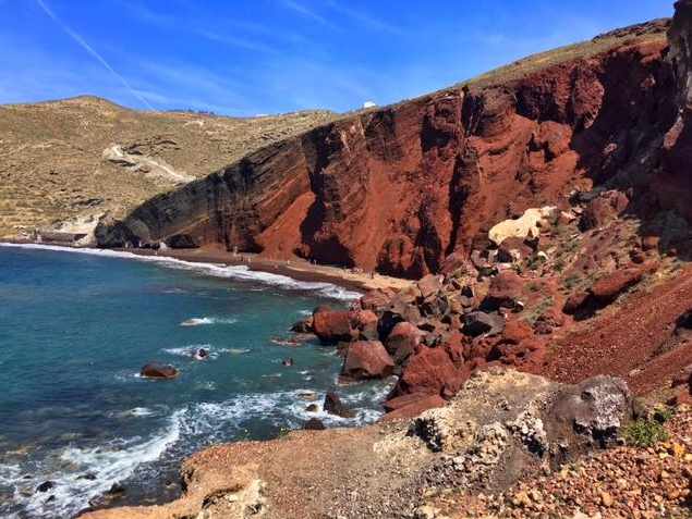
Red Beach is seen on a sunny April afternoon in a photo by TripAdvisor review contributor Chris B


Red Beach Santorini

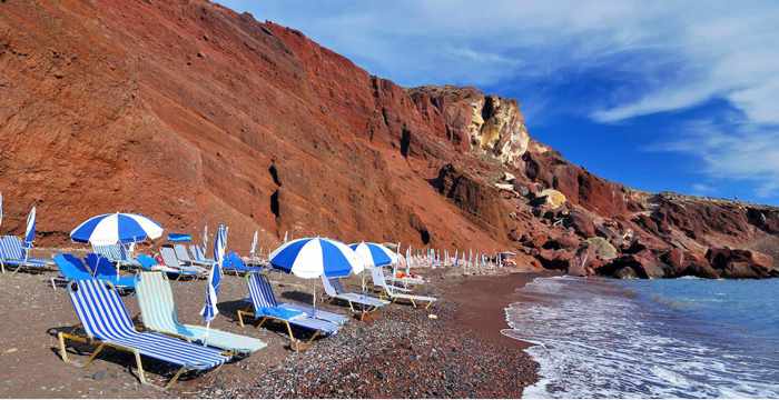
During peak season in past years, sunbeds have been available for rent, as seen in this photo from the Santorini Hotels Facebook page


Red Beach Santorini photo by Cecil Ramirez

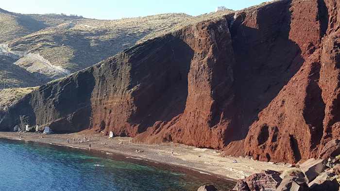
In April, Facebook member Cecil Ramirez captured this photo of the imposing red stone cliffs that tower above Red Beach


Red Beach Santorini photo by Daena K Nicholas

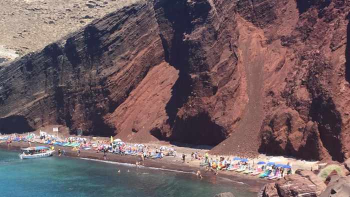
Major rockfalls have occurred at Red Beach several times in the past decade. Two of the larger landslides are clearly visible in this photo shared on Facebook by Daena K Nicholas


Red Beach Santorini photo by Jc Male

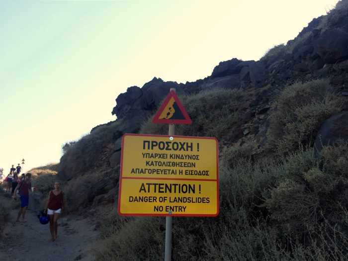
Red Beach has been “closed” since August 2013 because of fears more landslides could occur, and since stones and boulders loosen and plunge from the cliffs on occasion. But warning signs like this one, shown in a Facebook photo by Jc Male, have not deterred thousands of people from going to the beach.


Red Beach Santorini photo by Daniel Dias da Silva Facebook photo of Red Beach Santorini

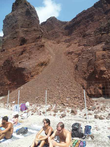
Sunbathers sit near the foot of one of the larger landslides, seen in a Facebook photo by Daniel Dias da Silva. Fences were installed to keep people from climbing the cliffs and landslip rubble because that could trigger further collapses of the rock face.


Red Beach Santorini photo by Nikky Dudek

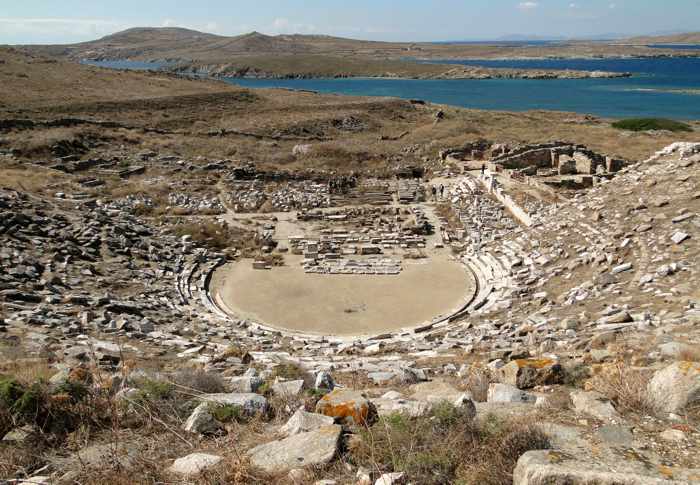
The safest way to see Red Beach is from the sea or from a distance on a hilltop vantage point like this one captured in a Facebook photo by Nikky Dudek


Please click on the link below to continue reading about Red Beach on page 2 of this post, where you can view videos and dozens more photos of this singular Santorini beach.


CONTINUED ON PAGE 2

Pages: 1 2

What’s new on Mykonos for summer 2016

Share

~ updated on Monday September 5 2016 ~


Mykonos Town and harbourfront

Overlooking the Mykonos Town harbourfront from one of my favourite vantage points on a hill behind the Remezzo area of town


Boom town: Many of the tourists who visited Mykonos last summer must have been wondering why they didn’t see obvious signs of the economic crisis that has ravaged the country for more than five years.  

Seemingly unscathed by the financial problems that have plagued the rest of Greece, Mykonos was absolutely thriving in 2015, with more than 100 new travel-related businesses opening up on the island last summer alone. The unprecedented renovation and building boom saw the arrival of new hotels, restaurants, bars, shops, galleries and personal services, many of which were aimed at the island’s rapidly growing luxury travel market.


It would be hard to top 2015’s astounding array of brand-new businesses again this year, but recent announcements about more upcoming new openings suggest the resilient Mykonos economy is poised for even further prosperity and growth.

So far there have been announcements on social media to herald the imminent debut of several new restaurants, retail shops, beach clubs, hotels, bars and nightlife venues, while rumours abound that many more are in the works.

Please click on the link below to read about the new businesses that have opened or been announced so far. I will update this post regularly as I receive more information about the newcomers.

CONTINUED ON PAGE 2

Pages: 1 2

Our brief intro to Tinos

Share

Tinos Town

With its distinctive rugged peak, Exomvourgo mountain dominates the scene as our ferry approaches the port at Tinos island


Ferry change: We got a brief introduction to Tinos during a short stopover for a ferry connection last May, and left the island wishing we had arranged to spend several days of our vacation there in between our visits to Andros and Syros.

We arrived at Tinos on the Superferry II from Andros shortly before noon on May 31, giving us sufficient time to explore part of Tinos Town and have lunch before returning to the port for our 3 p.m. ferry to Syros. So as soon as we disembarked the ship, we headed directly to the town’s main commercial area, a mere five-minute walk away.  


Donny B at Tinos port

At the Tinos port moments after arriving on a ferry from Andros. 


We were hoping to find a travel or ferry ticket office that offered luggage storage, so when we passed Epineio restaurant we asked one of the waiters if he could direct us to one. He called over his manager, who kindly offered to stow our bags inside the restaurant — at no charge — so we could explore the town unencumbered. When I promised we would soon return to have lunch, he said: “No obligation. Eat anywhere you like.” Minding our luggage, he explained, was meant as a small gesture of hospitality to welcome us to Tinos.  “We would like you to enjoy our beautiful island and we hope you will come back to stay here next time,” he said.

With that first good impression, we set off to walk around and see if we might be interested in returning to Tinos on a future trip to the Cyclades.


Epineio restaurant in Tinos

Epineio restaurant is situated on the side of a small square directly opposite the Hotel Lito and the Hotel Aigli 1876.  The manager let us leave our luggage in the restaurant while we walked around Tinos Town.


Considering that it was a Sunday, Tinos Town was far busier than we had expected — the streets and lanes near Epineio were teeming with people and actually were uncomfortably crowded in some spots. Then we remembered it was the middle of a holiday long weekend. Here we were, visiting one of the most popular Greek Orthodox pilgrimage destinations in Greece on the day before Holy Spirit Monday, so of course it would be busy!

Another surprise was that Tinos Town was significantly  bigger than we had been anticipating. I had imagined it to be a relatively small seaside village, like the port towns on Ios, Milos and Sifnos, but the port authority property was huge and the town extended quite a distance along the coast. This wasn’t a sleepy harbour village by any means, and we quickly realized we would get to see only a fraction of the town.  

Our plan was to stroll some of the streets, take a peek at the pilgrimage shrine that put Tinos on the map (the Church of Panagia Evaggelistria, also called Our Lady of Tinos), and then return to the waterfront area for a bite to eat.

Church of Panagia Evaggelistri

Tinos is famous for its Church of Panagia Evaggelistria (also called Our Lady of Tinos), built on the site where the Icon of the Annunciation of the Virgin Mary was discovered after a nun had a vision about its location.  Thousands of Greek Orthodox pilgrims visit the shrine each year.


CONTINUED ON PAGE 2

Pages: 1 2

Glimpses of Gavrio, and a ferry ride from Andros to Tinos

Share

Gavrio port at Andros

Gavrio harbourfront

The harbourfront at Gavrio, the port village on Andros island


Au revoir, Andros: When we arrived at Gavrio port on Andros at the start of our Greek holiday last May, we barely even noticed the village. Already groggy from our transatlantic travel and jet lag, we were struggling to shake off more cobwebs after dozing periodically during the ferry ride from Rafina. 

I saw a few shops and tavernas when we stepped off the ship, and can even remember thinking “there doesn’t seem to be much here” when I took a quick glance around. We didn’t have time for a longer look since we had to focus our attention on a more pressing issue — fitting luggage for four people into the compact car our friends had rented.

Soon we were pulling away from the port and driving up a narrow lane that squeezed tightly between rows of whitewashed houses before widening into the two-lane highway that would lead us to Andros Town. As we rounded a bend on the outskirts of Gavrio, we got our first views of exhilarating Andros scenery — fields, beaches and the wide open sea on our right side, and to our left a long line of mountains extending far into the distance.  It was a beautiful sight for our sore and very tired eyes.

View from highway on outskirts of Gavrio Andros

The mountain and sea view from the outskirts of Gavrio, seen in an image from Google Street View. This is the highway that leads from Gavrio to Batsi and onward to Andros Town.


We got a better look at Gavrio when we walked there from Batsi on the final full day of our Andros visit. As we turned onto the waterfront strip, we discovered there was much more to the town than we had seen while disembarking the ferry five days earlier.

On arrival day, we had basically seen just half of Gavrio’s commercial district — the extensive port authority area with its parking lots, loading zones, and of course the quays for ferries and ships, as well as a few of the businesses along the main street nearby.  We had not noticed that the street continued farther past the port, lined on one side with tavernas, shops and ferry ticket agencies, and a flagstone-paved walkway on the sea side. It took longer than we had anticipated to stroll the entire length of the road, and we were surprised by the large selection of restaurants and cafes — we had not been expecting to be so spoiled for choice in finding a place to have lunch. 

Though not as scenic as some other port towns in the Cyclades, Gavrio isn’t an unattractive place — it just doesn’t have the pretty, polished veneer of upscale boutiques and trendy cafe-bars that draw  the big-spending tourist and cruise ship crowds to places like Mykonos Town. And while Gavrio may be conveniently located for quick easy access to a variety of good beaches (see my post A bevy of beaches & coves on the scenic west coast of Andros), we were happy we had chosen to spend our holiday time at Andros Town and Batsi instead, since we preferred their overall look and feel.

Mind you, we didn’t walk around any of the residential streets on the hills tucked behind the waterfront strip, so we didn’t get to see all of Gavrio. We may have been more impressed had we taken time to explore beyond the port and harbourfront.

Gavrio harbourfront

We didn’t get to explore the residential streets on the hill behind the commercial waterfront strip


The next day we got more glimpses of Gavrio during a taxi ride to the port, followed by panoramic sea views of all of Gavrio Bay as we stood on the outdoor decks of the ferry taking us to Tinos. It was a brilliantly sunny morning, and Gavrio looked picturesque as it glistened in the sunshine.  I’m sure we’ll be back sometime for another look around.

Click on the link below to see more photos of Gavrio, as well as pictures of the Andros coast that we passed during our ferry trip to Tinos. There also are photos of the ship that took us there, the Superferry II, as well as the western coast of Tinos.

CONTINUED ON PAGE 2

Pages: 1 2

Visiting Delos in 2016

Share

 Delos island photo by Delos Tours

The “sacred island” of Delos is seen in a photo from the Google+ page for Delos Tours, the firm that runs ferries between Mykonos and Delos. 


Delos daytripping: It has been nearly two years since I last wrote about Delos island, and because there have been some noteworthy price changes for 2016, I’ve written this general information article to update my series of Top Delos Posts published from 2012 to 2014. (Apart from ferry schedules and the new prices for ferry tickets and admission to the Delos archaeological site, the information in my previous posts remains current.)


 What is Delos?

Here’s a brief background for readers who might not be familiar with Delos. The island, situated just over 2 km west of Mykonos, is one of the most important historic and archaeological sites in Greece. It’s often called “the sacred island” and “the island of light” because, in Greek mythology, it was the birthplace of Apollo, the god of light, and Artemis, the goddess of night light.

During its glory days between 166 BC and 69 BC, Delos was a wealthy shipping hub and one of the world’s leading centers of commerce. Home to more than 30,000 people, the city went into decline after it was looted and razed in two separate attacks; residents gradually left the island, and eventually Delos was abandoned completely and almost forgotten.


Delos island

The ruins of the Quarter of the Theater and the island’s once-great commercial port sprawl across the lower slopes of Mt Kynthos on Delos


Delos regained international attention when archaeologists began excavating its ruins in 1872. Small numbers of travellers, mainly from Europe, started visiting the island to view the fascinating historic sites that were gradually being unearthed. Over the decades, the trickle of tourists turned into a steady stream of sightseers from around the world, and today Delos is a top tourist attraction drawing more than 100,000 visitors each year. Delos is widely considered a “must see” attraction for people visiting Mykonos, and I personally recommend that visitors schedule a half-day trip to Delos during their Mykonos holidays, especially if it’s their first visit to Greece.

In 1990, Delos was added to the UNESCO World Heritage List. A description for UNESCO’s Delos listing says “The archaeological site is exceptionally extensive and rich and conveys the image of a great cosmopolitan Mediterranean port.”

And according to the Delos page on Visit Greece, the official tourism website for Greece, “nowhere else in the Globe is there a natural insular archaeological site of this size and importance. No other island on Earth hosts so many monumental antiquities from the Archaic, the Classical, and the Hellenistic periods, i.e. the centuries of the great Greek art, on a territory used exclusively as an archaeological site.”


What’s on Delos?

Delos Terrace of the Lions photo by Bernard Gagnon

The Terrace of the Lions is one of the most popular attractions on Delos island (Photo by Wikimedia contributor Bernard Gagnon)


All of Delos is a protected archaeological site, and visitors are not permitted to stay on the island overnight; hence, there are no accommodations (the nearest available lodging is on Mykonos). Besides the extensive ruins, which extend across most of the island, there is a museum that houses sculptures, wall paintings, pottery and thousands of small artefacts discovered during the excavations. A cafe in a separate building sells beverages and light snacks.

Some of the antiquities and sights most popular with tourists include: spectacular floor mosaics in the House of Dionysos, the House of the Dolphins, the House of the Mask, and the House of the Tritons; a marble amphitheater; several different agoras, sanctuaries and temples; the Sacred Lake and the Terrace of the Lions.


Delos Tours photo of mosaic in the House of the Dolphins on Delos

A detail of one of the colourful mosaics in the House of the Dolphins (Photo from the Delos Tours website.)


Bernard Gagnon Wikimedia Commons photo of Delos theater

The marble theater, seen in another image by Wikimedia contributor Bernard Gagnon, could seat up to 5,500 spectators


You’ll see many of the island’s top sights while a narrator describes the history of Delos in this informative 9.5-minute film by Expoza Travel.


Please click on the link below to continue reading on page 2, where you’ll find information about Delos ferry ticket and site admission prices, ferry schedules, guided tours, private charters to Delos, and more.

CONTINUED ON PAGE 2

Pages: 1 2

A bevy of beaches & coves on the scenic west coast of Andros

Share

Andros island west coast

 Looking along the west coast of Andros from a vantage point near Liopessi beach outside the town of Gavrio. More than a dozen places to sunbathe, swim and participate in water sports can be found along the 7 km stretch of seafront between Gavrio and Agia Marina.


a cove near Kipri beach on Andros

The coastline includes alluring small bays, inlets and quiet coves, like this one with warm golden sands near Kypri ….


Agios Petros beach Andros

… as well as several fully organized beaches, like Agios Petros, where sunbeds, bars, tavernas and water sports are available


Beach tour: Our final full day on Andros (Saturday May 30) was blessed with a mix of sun and clouds, warm temperatures and a slight breeze — perfect conditions for soaking up some sun and taking a dip at one of the island’s beautiful beaches.

But we were feeling too restless to simply laze away the day on a beach — our Andros visit was coming to an end, and we wanted to see more of the island before moving on to our next destination. So we spent the afternoon walking along the island’s west coast to have a look at all of the beaches situated between our hotel and the port town of Gavrio 7 kilometers to the north.

It took us about 3 hours to trek from Aneroussa Beach Hotel to the Gavrio harbourfront, following the two-lane highway that winds along the coast. It was a good way to enjoy the wonderful weather while seeing 10 main beaches — Agia Marina, Delavoyia, Stivari, Batsi, Kolona, Kyprianos, Kypri, Chrissi Ammos, Agios Petros, and Liopessi — plus the numerous coves and inlets that dot the scenic shoreline. It also gave us a chance to see more of Gavrio, which we had glimpsed only briefly when we arrived at the island five days earlier.

Our original plan was to walk all the way back from Gavrio, too, stopping for a drink at one of the beach bars along the way. But by the time we finished a late lunch in Gavrio, the sky was almost totally clear of clouds and the sun felt considerably hotter than it had during our hike to the port. Rather than risk sunburns, we took a taxi to Batsi, then walked from there to the Aneroussa hotel’s bar on Delavoyia beach, where we rested our tired feet and cooled off with some ice cold beer.

Though 10 beaches was a lot to visit in one day — far more than we typically see on our Greek island walkabouts — there were many others elsewhere on the island that we didn’t get to check out during our short time on Andros. They included Achla and Vitali, both of which often rank at the top of lists of the island’s “best” beaches, and Tis Grias to Pidima, which is pictured on scores of Andros postcards and travel guides. No worries — we’ll try to see  them on future trips to Andros. 

Please click on the link underneath the next two photos to continue reading  on page 2, where you can see pictures of all the beaches we visited on our coastal walk. I have also included links to websites with Andros beach information for those of you who might be planning to visit the island soon.


Liopessi beach on Andros

Besides beaches and coves, there is a lot of interesting scenery to view all along the Andros coast — like this curious rock formation at Liopessi beach …


hillside on the Andros coast near Batsi IMG_8416

 … along with steep hills dotted with houses and studio apartment buildings, as well as some impressive villas on sizable mountainside estates. The highway between Batsi and Gavrio also passes several tavernas, where the fragrant aromas of Greek cuisine will tempt your tastebuds as you walk by.


CONTINUED ON PAGE 2

Pages: 1 2

Sifnos island: A walker’s paradise

Share

You’ll wish you could head straight to Sifnos to take some scenic walks after watching this promotional film for the island’s network of footpaths


Trekker treat:  A video released just today has me aching to visit Sifnos to walk all over the island.

Sifnos Trails, hike on an authentic Greek Island! is a nearly 6-minute-long promotional film that spotlights the island’s vast network of professionally signposted hiking trails. With fabulous aerial and trail-level videography by Photo Kontos, the video is bound to inspire legions of trekking enthusiasts to visit Sifnos to explore some or all of the 19 different trails that extend more than 100 kilometers in total.

As you would expect,  the film features beautiful mountain, valley, village and coastal scenery. What’s also impressive is the expertly-developed way-marking system, shown in the video, that helps guide trekkers along the trails. Viewers also are informed of a free app for Android smartphones, and are directed to a Sifnos Trails website that provides extensive information about the island and its paths, downloadable route maps, and galleries of gorgeous island images by four photographers.


Giorgos Zampelis photo of Sifnos Trail 10A

The Sifnos Trails website includes photo galleries featuring beautiful images by Giorgos Zampelis and three other photographers. There are hundreds of photos on the Sifnos Trails Facebook page, too.


When we visited Sifnos in 2007, we knew that the island had an extensive network of footpaths, but they weren’t easy to find or follow. I bought a booklet that described more than two dozen hiking itineraries, but the directions for the first three walks that we attempted led us to dead ends (quite literally — we wound up in a cemetery on one hike!) We eventually gave up on the brochure and simply wandered around. It was good fun nonetheless, but signposts and directional markings would have helped us see far more of the island.

When I discovered the Sifnos Trails video today, I immediately wondered when the way-marking system had been implemented, since I had heard nothing about it. Turns out that the island municipality undertook the Sifnos Trails project in 2015, collaborating with Paths of Greece to improve the trail network to “help the island’s visitors explore its natural and cultural beauties in a pleasant way.” The project is funded and managed by the municipality of Sifnos.

Besides the website the Android app, there is a Sifnos Trails Facebook page with further information and hundreds of photos of hiking paths and stunning Sifnos scenery.

If you’re planning to visit Sifnos this summer, be sure to bookmark the website and Facebook pages so you can read up on the walking routes before going.

Happy trekking once you’re there!

[Editor’s Updates: The Greek edition of The Huffington Post published an interesting article about Sifnos Trails on March 5, which you can see by clicking here.  If you don’t understand Greek, you can use a program like Google Translate to read the article. And on March 10, Sifnos Trails added to its website Google Trekker digital tours of several of its walking routes.]


Sifnos Trails website

A screenshot of the home page for the Sifnos Trails website, which describes the island’s trail project and provides extensive information about the routes and the island in general.


Sifnos Trails information page for one of the 19 walking routes

The website provides detailed descriptions and maps for each of the 19 walking routes, along with helpful tips and advice. This is a screenshot of the information page for Trail 9 (Kambanario — Cherronisos). 


screenshot of waymarking page on Sifnos Trails website

Signposts and painted markings helpfully point the way along the island’s various walking routes

Older posts Newer posts