Category: Greek Islands (Page 20 of 93)

Glimpses of Gavrio, and a ferry ride from Andros to Tinos

Share

Gavrio port at Andros

Gavrio harbourfront

The harbourfront at Gavrio, the port village on Andros island


Au revoir, Andros: When we arrived at Gavrio port on Andros at the start of our Greek holiday last May, we barely even noticed the village. Already groggy from our transatlantic travel and jet lag, we were struggling to shake off more cobwebs after dozing periodically during the ferry ride from Rafina. 

I saw a few shops and tavernas when we stepped off the ship, and can even remember thinking “there doesn’t seem to be much here” when I took a quick glance around. We didn’t have time for a longer look since we had to focus our attention on a more pressing issue — fitting luggage for four people into the compact car our friends had rented.

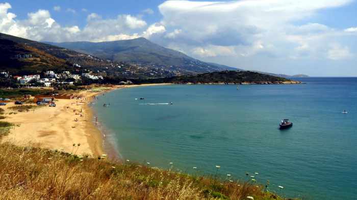
Soon we were pulling away from the port and driving up a narrow lane that squeezed tightly between rows of whitewashed houses before widening into the two-lane highway that would lead us to Andros Town. As we rounded a bend on the outskirts of Gavrio, we got our first views of exhilarating Andros scenery — fields, beaches and the wide open sea on our right side, and to our left a long line of mountains extending far into the distance.  It was a beautiful sight for our sore and very tired eyes.

View from highway on outskirts of Gavrio Andros

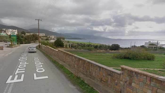
The mountain and sea view from the outskirts of Gavrio, seen in an image from Google Street View. This is the highway that leads from Gavrio to Batsi and onward to Andros Town.


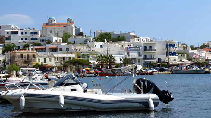
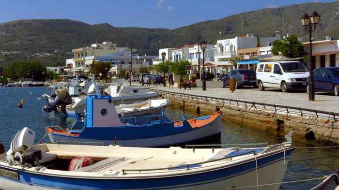
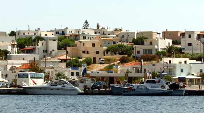
We got a better look at Gavrio when we walked there from Batsi on the final full day of our Andros visit. As we turned onto the waterfront strip, we discovered there was much more to the town than we had seen while disembarking the ferry five days earlier.

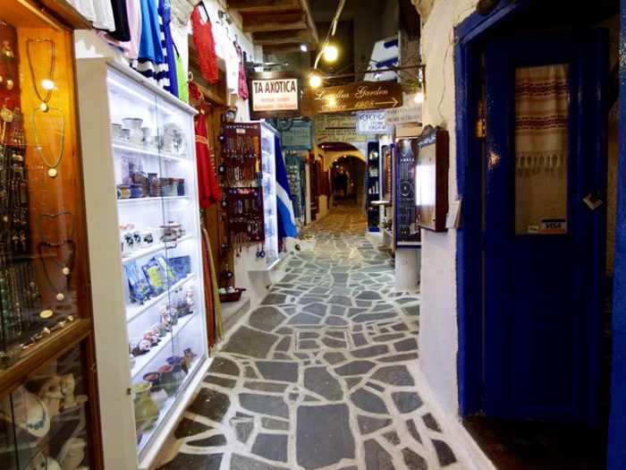
On arrival day, we had basically seen just half of Gavrio’s commercial district — the extensive port authority area with its parking lots, loading zones, and of course the quays for ferries and ships, as well as a few of the businesses along the main street nearby.  We had not noticed that the street continued farther past the port, lined on one side with tavernas, shops and ferry ticket agencies, and a flagstone-paved walkway on the sea side. It took longer than we had anticipated to stroll the entire length of the road, and we were surprised by the large selection of restaurants and cafes — we had not been expecting to be so spoiled for choice in finding a place to have lunch. 

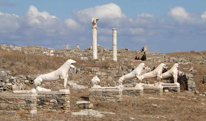
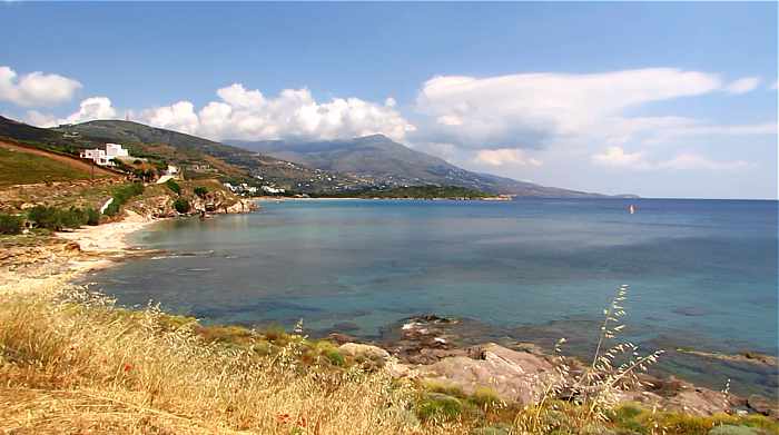
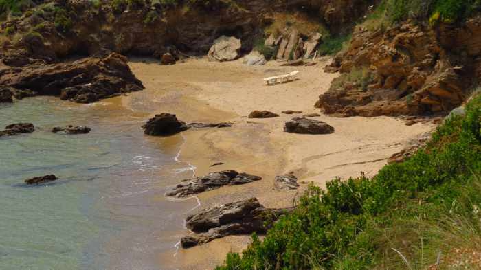
Though not as scenic as some other port towns in the Cyclades, Gavrio isn’t an unattractive place — it just doesn’t have the pretty, polished veneer of upscale boutiques and trendy cafe-bars that draw  the big-spending tourist and cruise ship crowds to places like Mykonos Town. And while Gavrio may be conveniently located for quick easy access to a variety of good beaches (see my post A bevy of beaches & coves on the scenic west coast of Andros), we were happy we had chosen to spend our holiday time at Andros Town and Batsi instead, since we preferred their overall look and feel.

Mind you, we didn’t walk around any of the residential streets on the hills tucked behind the waterfront strip, so we didn’t get to see all of Gavrio. We may have been more impressed had we taken time to explore beyond the port and harbourfront.

Gavrio harbourfront

We didn’t get to explore the residential streets on the hill behind the commercial waterfront strip


The next day we got more glimpses of Gavrio during a taxi ride to the port, followed by panoramic sea views of all of Gavrio Bay as we stood on the outdoor decks of the ferry taking us to Tinos. It was a brilliantly sunny morning, and Gavrio looked picturesque as it glistened in the sunshine.  I’m sure we’ll be back sometime for another look around.

Click on the link below to see more photos of Gavrio, as well as pictures of the Andros coast that we passed during our ferry trip to Tinos. There also are photos of the ship that took us there, the Superferry II, as well as the western coast of Tinos.

CONTINUED ON PAGE 2

Considering Corfu for your next holiday? These videos may convince you to go

Share

Take a 3-minute aerial cruise above Corfu in this newly-released video, produced on behalf of the island’s port authority


Video vacation: I feel like I have just taken an extensive and exhausting (but in a good way) sightseeing trip to Corfu — even though I haven’t been there yet. And courtesy of several online videos I’ve been watching the past couple of days, it’s entirely possible that I may have just seen more of the island from here at home than I might have been able to see had I actually been on Corfu for the same period of time.

On March 14, a link to Corfu, the Garden of Gods (above) popped up in my social media news feeds, and I watched the film a few times.  The three-minute aerial video was shared by Vangelis Koulouris,  who said the short clip “was created for the Port Authority of Corfu with a view to highlight the unique environment and the multicultural history of Corfu island.”

The film features soaring views of Corfu’s lush landscapes, its picturesque coastlines and beaches, the island’s beautiful capital (also called Corfu), and cruise ships calling at its port. Corfu is, of course, one of the top Greek island destinations for cruise ships, so a video by its port authority just wouldn’t seem complete without at least a few passenger liners appearing in the picture.

As tends to happen whenever I find something interesting on social media, one thing led to another — and before long I had compiled a playlist of several more Corfu videos to view.  But except for Garden of the Gods, and another 3-minute clip, the other films weren’t as short and sweet — with run times ranging from 10 and 24 minutes to nearly two hours, they were the equivalent of watching a few evenings of TV programs. But I considered it “time well wasted,” as the saying goes.

It’s time some of you might wish to spend, too, should you be considering Corfu for an upcoming or future vacation — or should you simply want to see what the island is all about. To that end, I have posted some of the videos below. Four of the six films (including the one above) were  published just within the last several weeks, while two were released last year. What I appreciated most about the videos is that they either show or tell you the names of places you’re looking at — something all too many travel videos fail to do. 

If you manage to make it through all the clips, you’ll probably feel like you’ve just gone to the island, too — or attended a Corfu film festival!


My Corfu in 3 minutes is a quick-view highlight version of the considerably longer My Corfu, which is posted directly below.  Produced by Petros Kapsokavadis and the Oasis Hotel in Perama, it’s intended for viewers who don’t have enough time to watch the full-length clip.


This is the full 24-minute My Corfu video by Petros Kapsokavadis and the Oasis hotel. Most of the clip is aerial videography of places all around the island, but there is a segment showing part of the Corfu Mountain Trail footpath from Perama to Gastouri. 


Corfu — the island of eternal returns is a 10-minute film released just this month by the Mouzenidis Group of companies. A guide takes viewers on a tour of many of Corfu’s marvellous attractions, sights and scenery while describing highlights of the island’s history.


Corfu Coast Line is an aerial tour around the Corfu coast. The 48-minute film is a project of Corfu Benitses, the Association for Culture and Redevelopment of Benitses, a fishing village 12 km from Corfu city. 


The Corfu Vacation Travel Video Guide title says it all! Nearly 58 minutes long, the informative narrated film is a production of Exposa Travel.


My Movie Corfu Trail clocks in at 1 hour and 50 minutes but it is, after all, a video diary of a 10-day, 150-mile trek around the island that Tim Beal and a friend took last September.  “It is a fantastic walk and should be a tonic for all who like fine views, fine food and great people. Take two weeks out and walk Corfu… you will love it!” Tim says. If you don’t have the energy to attempt the walk yourself, simply sit back and watch Tim and his friend do it instead!

Naxos: The quietly traditional heart of the Cyclades islands

Share

Mike Andrew photo of a lane in Naxos Town

Shops line a narrow lane in the historic Old Market district of Naxos Town. Photo by Mike Andrew.


Sitting at the heart of the Aegean, can the unassuming and traditionally minded Naxos hold its own against its cosmopolitan neighbours?


Guest post by James Andrew

The shutters bang and clatter against the window. The howling, whistling noises coming from outside are more than a little disconcerting. The meltemi, the strong warming wind that blows constantly through the Aegean at this time of year, is definitely strong today.

Looking out of our villa window at the large, agriculturally rich fields, curious, twisted rock formations and, in the distance, the somewhat foreboding Mount Zas silhouetted against the dusk skyline, this all feels slightly alien. Certainly it’s a world away from the cosmopolitan and touristy island of Santorini from which we caught the ferry earlier in the day. No, this is very different. This is the much less visited and certainly less known island of Naxos.

Positioned at the heart of the Cycladic (or White) Islands, Naxos sits somewhat oddly next to its much-lauded neighbours Santorini, Mykonos and Paros. Whilst the island has gradually been building a fan base amongst Greece afficionados in the know, it still remains defiantly off the main cruise routes. Its main port in Naxos Town sees the arrival of daily ferries but no towering cruise ship behemoths like the ones that anchor in Santorini’s caldera.

The highest peak in the Cyclades, Mount Zas dominates the island. Breaking from the image of barren, volcanic lunar landscapes one most associates with this area of Greece, Naxos is blessed by nature. Green and verdant throughout, it defies convention. So, how would this island that lacks Santorini’s chic, polished veneer and Mykonos’ cool, hipster vibe reveal itself? Can it compete with its upmarket neighbours? We cracked the rattling shutters open and stepped into the wind to find out.


Fish Olive Creations Facebook page photo of Mount Zas on Naxos

A view of Mount Zas, Filoti village and Halki village (bottom). Photo by the Fish & Olive Creations art gallery and shop in Halki.


Please click on the link below to continue reading and view more photos.

CONTINUED ON PAGE 2

Video perspectives of Patmos island

Share

This is one of two aerial videos that the Municipality of Patmos released in early March to promote the charming isle, located in the Dodecanese chain of islands. The municipality’s other official film appears below.


Simply delightful: We have enjoyed every island we have visited in Greece, but some simply feel more comfortable, delightful and memorable than others. Patmos is one of them.

Although we have been to Patmos only once,  for four days in May 2010, it feels like it was just  yesterday — our memories of how the island looked and felt remain razor-sharp and almost palpable. 

Those feelings got tweaked a little last week when the Municipality of Patmos released two official videos to promote the island for 2016. The aerial film of the island’s beautiful sights and scenery included views of many places we saw six years ago, along with others we didn’t have enough time to visit. Surprisingly, the light and shadows in some of the video scenes looked the same as when we were there — particularly when the camera captures locations bathed in the golden glow of the setting sun.   

The clips include views of the island’s port town, Skala, the fortress-like Monastery of St John, Chora village, Grikos Bay, Kalikatsou Rock, and several of the island’s beautiful bays and beaches.

Watching the films has been a reminder that we’ve got to get back to Patmos to re-experience its charms and enchanting atmosphere. And to enjoy another serving (or two or three) of the absolutely amazing roasted chickpeas from Flisvos Taverna ….


Visiting Delos in 2016

Share

 Delos island photo by Delos Tours

The “sacred island” of Delos is seen in a photo from the Google+ page for Delos Tours, the firm that runs ferries between Mykonos and Delos. 


Delos daytripping: It has been nearly two years since I last wrote about Delos island, and because there have been some noteworthy price changes for 2016, I’ve written this general information article to update my series of Top Delos Posts published from 2012 to 2014. (Apart from ferry schedules and the new prices for ferry tickets and admission to the Delos archaeological site, the information in my previous posts remains current.)


 What is Delos?

Here’s a brief background for readers who might not be familiar with Delos. The island, situated just over 2 km west of Mykonos, is one of the most important historic and archaeological sites in Greece. It’s often called “the sacred island” and “the island of light” because, in Greek mythology, it was the birthplace of Apollo, the god of light, and Artemis, the goddess of night light.

During its glory days between 166 BC and 69 BC, Delos was a wealthy shipping hub and one of the world’s leading centers of commerce. Home to more than 30,000 people, the city went into decline after it was looted and razed in two separate attacks; residents gradually left the island, and eventually Delos was abandoned completely and almost forgotten.


Delos island

The ruins of the Quarter of the Theater and the island’s once-great commercial port sprawl across the lower slopes of Mt Kynthos on Delos


Delos regained international attention when archaeologists began excavating its ruins in 1872. Small numbers of travellers, mainly from Europe, started visiting the island to view the fascinating historic sites that were gradually being unearthed. Over the decades, the trickle of tourists turned into a steady stream of sightseers from around the world, and today Delos is a top tourist attraction drawing more than 100,000 visitors each year. Delos is widely considered a “must see” attraction for people visiting Mykonos, and I personally recommend that visitors schedule a half-day trip to Delos during their Mykonos holidays, especially if it’s their first visit to Greece.

In 1990, Delos was added to the UNESCO World Heritage List. A description for UNESCO’s Delos listing says “The archaeological site is exceptionally extensive and rich and conveys the image of a great cosmopolitan Mediterranean port.”

And according to the Delos page on Visit Greece, the official tourism website for Greece, “nowhere else in the Globe is there a natural insular archaeological site of this size and importance. No other island on Earth hosts so many monumental antiquities from the Archaic, the Classical, and the Hellenistic periods, i.e. the centuries of the great Greek art, on a territory used exclusively as an archaeological site.”


What’s on Delos?

Delos Terrace of the Lions photo by Bernard Gagnon

The Terrace of the Lions is one of the most popular attractions on Delos island (Photo by Wikimedia contributor Bernard Gagnon)


All of Delos is a protected archaeological site, and visitors are not permitted to stay on the island overnight; hence, there are no accommodations (the nearest available lodging is on Mykonos). Besides the extensive ruins, which extend across most of the island, there is a museum that houses sculptures, wall paintings, pottery and thousands of small artefacts discovered during the excavations. A cafe in a separate building sells beverages and light snacks.

Some of the antiquities and sights most popular with tourists include: spectacular floor mosaics in the House of Dionysos, the House of the Dolphins, the House of the Mask, and the House of the Tritons; a marble amphitheater; several different agoras, sanctuaries and temples; the Sacred Lake and the Terrace of the Lions.


Delos Tours photo of mosaic in the House of the Dolphins on Delos

A detail of one of the colourful mosaics in the House of the Dolphins (Photo from the Delos Tours website.)


Bernard Gagnon Wikimedia Commons photo of Delos theater

The marble theater, seen in another image by Wikimedia contributor Bernard Gagnon, could seat up to 5,500 spectators


You’ll see many of the island’s top sights while a narrator describes the history of Delos in this informative 9.5-minute film by Expoza Travel.


Please click on the link below to continue reading on page 2, where you’ll find information about Delos ferry ticket and site admission prices, ferry schedules, guided tours, private charters to Delos, and more.

CONTINUED ON PAGE 2

The captivating coast, beach and village scenery at Kokkari on Samos

Share

Kokkari Village 2016 features breathtaking bird’s eye views of the scenic seafronts and harbour at Kokkari village on Samos 


Picture-postcard perfect:  We’ve got a lot of happy memories from our trip to Samos six years ago, and some of the best are from our visit to Kokkari one afternoon.

We had rented mountain bikes in Vathy for a day, and cycled to Kokkari to get a first-hand look at the village mainly because an online acquaintance had recommended it as a “must see” spot on the island. She warned me that it’s “super-popular” with tourists, but said we would love it nonetheless because “it’s just so gosh-darned pretty and picturesque — everything looks like a picture on a postcard.”

She wasn’t kidding when she cautioned us about the “touristy” side to Kokkari — we couldn’t believe the astounding number of bar, cafe and taverna signs we saw on the popular dining strip along the village harbour. (Take a quick peek at the photos in my posts Kokkari’s waterfront restaurant row, and What’s cooking in Kokkari? and you’ll see what I mean.) Although the signage suggested there might be cutthroat competition between the village’s dozens of eateries, we found Kokkari had a surprisingly laid-back atmosphere, and we didn’t encounter any of those annoying restaurant touts who try to coax and cajole people into patronizing some establishments on Naxos, Kos and Mykonos.

Gorgeous scenery and photo opps galore

My friend was absolutely right about the village’s picture-postcard appeal, too. There was gorgeous scenery all around, and photo opportunities galore — striking beach and coastal scenery, quaint lanes and alleys, the colourful village harbour, and the impressive backdrop of Mount Karvouris. We’ll certainly pay Kokkari another visit next time we’re on Samos.

The video I posted above, which was produced by the aerial photography firm Reel Drone, shows much of the village and coastal scenery that we found so captivating back in 2010 — even though it is, of course, filmed from a completely different perspective than tourists get to see while strolling around the area.

If you have been to Kokkari before, the video will probably bring back pleasant memories of your own. If you haven’t visited it yet (or haven’t even been to Samos), I’m sure you’ll enjoy the 2-minute aerial tour and find it inspiring for future holiday planning.

Kokkari website links

And just in case you might be thinking about a trip to Samos, the people at Reel Drone have offered the following helpful links to online information about Kokkari:

♦  https://www.facebook.com/Κοκκαρι-Δημοτικη-Κοινοτητα-1411154232520­339/

http://www.kokkari.gr/


A bevy of beaches & coves on the scenic west coast of Andros

Share

Andros island west coast

 Looking along the west coast of Andros from a vantage point near Liopessi beach outside the town of Gavrio. More than a dozen places to sunbathe, swim and participate in water sports can be found along the 7 km stretch of seafront between Gavrio and Agia Marina.


a cove near Kipri beach on Andros

The coastline includes alluring small bays, inlets and quiet coves, like this one with warm golden sands near Kypri ….


Agios Petros beach Andros

… as well as several fully organized beaches, like Agios Petros, where sunbeds, bars, tavernas and water sports are available


Beach tour: Our final full day on Andros (Saturday May 30) was blessed with a mix of sun and clouds, warm temperatures and a slight breeze — perfect conditions for soaking up some sun and taking a dip at one of the island’s beautiful beaches.

But we were feeling too restless to simply laze away the day on a beach — our Andros visit was coming to an end, and we wanted to see more of the island before moving on to our next destination. So we spent the afternoon walking along the island’s west coast to have a look at all of the beaches situated between our hotel and the port town of Gavrio 7 kilometers to the north.

It took us about 3 hours to trek from Aneroussa Beach Hotel to the Gavrio harbourfront, following the two-lane highway that winds along the coast. It was a good way to enjoy the wonderful weather while seeing 10 main beaches — Agia Marina, Delavoyia, Stivari, Batsi, Kolona, Kyprianos, Kypri, Chrissi Ammos, Agios Petros, and Liopessi — plus the numerous coves and inlets that dot the scenic shoreline. It also gave us a chance to see more of Gavrio, which we had glimpsed only briefly when we arrived at the island five days earlier.

Our original plan was to walk all the way back from Gavrio, too, stopping for a drink at one of the beach bars along the way. But by the time we finished a late lunch in Gavrio, the sky was almost totally clear of clouds and the sun felt considerably hotter than it had during our hike to the port. Rather than risk sunburns, we took a taxi to Batsi, then walked from there to the Aneroussa hotel’s bar on Delavoyia beach, where we rested our tired feet and cooled off with some ice cold beer.

Though 10 beaches was a lot to visit in one day — far more than we typically see on our Greek island walkabouts — there were many others elsewhere on the island that we didn’t get to check out during our short time on Andros. They included Achla and Vitali, both of which often rank at the top of lists of the island’s “best” beaches, and Tis Grias to Pidima, which is pictured on scores of Andros postcards and travel guides. No worries — we’ll try to see  them on future trips to Andros. 

Please click on the link underneath the next two photos to continue reading  on page 2, where you can see pictures of all the beaches we visited on our coastal walk. I have also included links to websites with Andros beach information for those of you who might be planning to visit the island soon.


Liopessi beach on Andros

Besides beaches and coves, there is a lot of interesting scenery to view all along the Andros coast — like this curious rock formation at Liopessi beach …


hillside on the Andros coast near Batsi IMG_8416

 … along with steep hills dotted with houses and studio apartment buildings, as well as some impressive villas on sizable mountainside estates. The highway between Batsi and Gavrio also passes several tavernas, where the fragrant aromas of Greek cuisine will tempt your tastebuds as you walk by.


CONTINUED ON PAGE 2

Sifnos island: A walker’s paradise

Share

You’ll wish you could head straight to Sifnos to take some scenic walks after watching this promotional film for the island’s network of footpaths


Trekker treat:  A video released just today has me aching to visit Sifnos to walk all over the island.

Sifnos Trails, hike on an authentic Greek Island! is a nearly 6-minute-long promotional film that spotlights the island’s vast network of professionally signposted hiking trails. With fabulous aerial and trail-level videography by Photo Kontos, the video is bound to inspire legions of trekking enthusiasts to visit Sifnos to explore some or all of the 19 different trails that extend more than 100 kilometers in total.

As you would expect,  the film features beautiful mountain, valley, village and coastal scenery. What’s also impressive is the expertly-developed way-marking system, shown in the video, that helps guide trekkers along the trails. Viewers also are informed of a free app for Android smartphones, and are directed to a Sifnos Trails website that provides extensive information about the island and its paths, downloadable route maps, and galleries of gorgeous island images by four photographers.


Giorgos Zampelis photo of Sifnos Trail 10A

The Sifnos Trails website includes photo galleries featuring beautiful images by Giorgos Zampelis and three other photographers. There are hundreds of photos on the Sifnos Trails Facebook page, too.


When we visited Sifnos in 2007, we knew that the island had an extensive network of footpaths, but they weren’t easy to find or follow. I bought a booklet that described more than two dozen hiking itineraries, but the directions for the first three walks that we attempted led us to dead ends (quite literally — we wound up in a cemetery on one hike!) We eventually gave up on the brochure and simply wandered around. It was good fun nonetheless, but signposts and directional markings would have helped us see far more of the island.

When I discovered the Sifnos Trails video today, I immediately wondered when the way-marking system had been implemented, since I had heard nothing about it. Turns out that the island municipality undertook the Sifnos Trails project in 2015, collaborating with Paths of Greece to improve the trail network to “help the island’s visitors explore its natural and cultural beauties in a pleasant way.” The project is funded and managed by the municipality of Sifnos.

Besides the website the Android app, there is a Sifnos Trails Facebook page with further information and hundreds of photos of hiking paths and stunning Sifnos scenery.

If you’re planning to visit Sifnos this summer, be sure to bookmark the website and Facebook pages so you can read up on the walking routes before going.

Happy trekking once you’re there!

[Editor’s Updates: The Greek edition of The Huffington Post published an interesting article about Sifnos Trails on March 5, which you can see by clicking here.  If you don’t understand Greek, you can use a program like Google Translate to read the article. And on March 10, Sifnos Trails added to its website Google Trekker digital tours of several of its walking routes.]


Sifnos Trails website

A screenshot of the home page for the Sifnos Trails website, which describes the island’s trail project and provides extensive information about the routes and the island in general.


Sifnos Trails information page for one of the 19 walking routes

The website provides detailed descriptions and maps for each of the 19 walking routes, along with helpful tips and advice. This is a screenshot of the information page for Trail 9 (Kambanario — Cherronisos). 


screenshot of waymarking page on Sifnos Trails website

Signposts and painted markings helpfully point the way along the island’s various walking routes

« Older posts Newer posts »

© 2026

Theme by Anders NorenUp ↑