Category: Greek Islands videos (Page 7 of 19)

The bewitching but dangerous beauty of Santorini’s Red Beach

Share

Red Beach Santorini

Santorini’s Red Beach is seen in an image from EscapeGreece.com 


[Editor’s Update: If you plan to visit Santorini in 2018, please beware that Red Beach is officially closed to the public. Click here to read about a landslide that occurred on Red Beach in April 2018 and led island authorities to re-issue warnings that the beach is off limits because it’s too dangerous to visit.] 


Rockfall risk: Since Santorini enjoys a worldwide reputation for superlative natural scenery, it’s not surprising that the island’s remarkable Red Beach regularly garners glowing accolades from international travel publications and leading lifestyle websites — along with ample attention on social media, where thousands of people have posted selfies that they shot on and near the colourful coastal attraction.

During my routine online work and research, I frequently find articles in which travel magazines and websites declare Red Beach to be one of the world’s “best,” “most beautiful,” “most unusual” or “most colourful” beaches, and recommend it as a “must-see” for anyone visiting Santorini.  Photos of the distinctive strand, which is also known as Red Sand Beach, appear even more often on websites and social media pages dedicated to travel in Greece, and in particular for hotels and tour companies operating on Santorini.


[adToAppearHere]


What the articles, posts and photo captions rarely mention, however, is that Red Beach is a veritably perilous place to sunbathe, swim or stroll. In recent years, there have been several significant rockfalls and landslides from the crimson-coloured bluffs that rise behind the narrow strip of scarlet-tinged pebbles and stones, and geological experts believe it’s possible that more cliff sections could collapse onto the beach at any time. (There are anecdotal claims that two beachgoers were killed by a landslide a few years ago, but I couldn’t find any news reports confirming the fatalities or date of the accident.)


Red Beach Santorini photo by TripAdvisor member Chris B

Red Beach is seen on a sunny April afternoon in a photo by TripAdvisor review contributor Chris B


Red Beach Santorini

During peak season in past years, sunbeds have been available for rent, as seen in this photo from the Santorini Hotels Facebook page


Red Beach Santorini photo by Cecil Ramirez

In April, Facebook member Cecil Ramirez captured this photo of the imposing red stone cliffs that tower above Red Beach


Red Beach Santorini photo by Daena K Nicholas

Major rockfalls have occurred at Red Beach several times in the past decade. Two of the larger landslides are clearly visible in this photo shared on Facebook by Daena K Nicholas


Red Beach Santorini photo by Jc Male

Red Beach has been “closed” since August 2013 because of fears more landslides could occur, and since stones and boulders loosen and plunge from the cliffs on occasion. But warning signs like this one, shown in a Facebook photo by Jc Male, have not deterred thousands of people from going to the beach.


Red Beach Santorini photo by Daniel Dias da Silva Facebook photo of Red Beach Santorini

Sunbathers sit near the foot of one of the larger landslides, seen in a Facebook photo by Daniel Dias da Silva. Fences were installed to keep people from climbing the cliffs and landslip rubble because that could trigger further collapses of the rock face.


Red Beach Santorini photo by Nikky Dudek

The safest way to see Red Beach is from the sea or from a distance on a hilltop vantage point like this one captured in a Facebook photo by Nikky Dudek


Please click on the link below to continue reading about Red Beach on page 2 of this post, where you can view videos and dozens more photos of this singular Santorini beach.


CONTINUED ON PAGE 2

Sky views of Santorini’s sensational cliffside scenery

Share


Drone tour: Here’s a video to excite and inspire those of you who will be going to Santorini this summer — or possibly sometime in the future.

Created by NPro+ Aerial Production, the two-and-a-half minute film will take you on an exhilarating aerial tour of the western side of Santorini, renowned for the picturesque villages that cling to the peaks of rugged caldera cliffs towering nearly 1,000 feet (300 meters) above the Aegean Sea.

Although dozens of drone videos of Santorini are available for online viewing, I particularly like NPro+’s Santorini from the Sky because it starts with a superb view of Agios Theodori, the church that has been pictured on countless Santorini postcards, posters and travel guides.


[adToAppearHere]


Instantly recognizable by its shiny blue dome and brilliant white belltower overlooking the volcano island of Nea Kameni, Agios Theodori church was the first fascinating sight we saw moments after arriving at our hotel in Firostefani village on our first visit to Santorini in 2004. The video goes on to show other remarkable scenes that amazed us throughout that holiday, including views of four clifftop villages — Fira, Firostefani, Imerovigli and Oia — and beautiful Amoudi Bay below Oia. Of course, the film also shows some of the sensational sunsets for which Santorini is famous around the world.

Scenes from some of the shop-lined streets in the heart of Fira, and from a few of its many cliffside cocktail bars and cafes, also made me feel like I was right back on the island experiencing it in person all over again.

The only thing I didn’t like was the brief view of tourists riding donkeys on the path that winds down the cliff from Fira to the cruise ship tender port. Click here to read why you shouldn’t take a donkey ride if you visit Santorini.

Agios Theodori church in Firostefani

Even if you’ve never been to Santorini, you’ve probably seen Agios Theodori church — it has been pictured on scores of postcards, posters and travel guides. Located in Firostefani village, it was the first impressive sight we saw on our first visit to Santorini back in 2004. There’s a great view of the church, and the Nea Kameni volcano island (upper left), at the beginning of the Santorini from the Sky video I posted above.

The scenic charms of Serifos

Share


Beautiful Serifos scenery is spotlighted in the two aerial videos above, both of which were shared online by YouTube contributor Loris Trian.  Click on the arrows to view the films.


Cycladic gem: One of my readers has been asking where she should look on the blog to find photos and reports from our trips to Serifos, as she’s been having trouble tracking them down. Unfortunately, there aren’t any — purely because we haven’t been to Serifos yet.

But since it’s one of the many places on our bucket list of islands to see in Greece, I have been bookmarking Serifos websites and videos I come across so the links are handy for future reference.

Rather than just pass that information along in an email reply, I’m posting the links and three of the videos here in case other readers considering a holiday on Serifos might find them interesting and helpful.


[adToAppearHere]


Besides reading many good things about Serifos, I have heard only positive feedback about it from well-travelled friends and contacts who have highly recommended paying the West Cyclades island a visit. Several have used the words “wonderful” and “gem” to describe it, and “gem” is exactly what some online travel sites have called it as well. A few of the people I have spoken to are repeat visitors to Serifos, and have been to other islands that my partner and I have visited and enjoyed. They have assured me that we would not be disappointed with Serifos, and would find it just as delightful as our favourite isles.

Below are links to three travel websites specifically dedicated to Serifos. Confusingly, they all have the words “Serifos Island” in their titles, but they’ll take you to three completely different sites:

♦  Serifos Island Greece

♦  Serifos Island

♦  Serifos-island 


Below are links to several major Greece travel websites that offer photos, travel guides and general visitor information for Serifos:

♦ The Serifos page on The Greek Travel 

♦ The Serifos travel guide on the Cycladia travel portal

♦  The Serifos holiday guide on the Greeka specialty website for Greek island travel

♦ The Serifos information page from the Discover Greece website for Greece tourism


And last but not here, here is another aerial video of Serifos:

Explore Serifos from the air in this 6-minute film by Photo Kontos

In the works: ‘Street views’ of Crete’s trekking trails

Share

This 16-minute videoclip shows several popular hiking routes on Crete being photographed for Google Trekker — a version of the popular Street View feature on Google Maps


Crete on foot: Hiking enthusiasts may soon see what Crete’s trekking paths look like without having to take a single step on any of the trails.

The Region of Crete and Google are participating in a project to photograph some of Crete’s major hiking routes for Google Trekker, a version of the company’s popular Street View app that lets people take virtual tours of places from their computers and mobile devices. The Trekker program has an ambitious goal of mapping the world — including out-of-the-way and hard-to-reach places where camera-equipped vehicles can’t travel. Footpaths are filmed by hikers who walk the routes wearing a backpack equipped with Google Trekker photography equipment.

The video above was published on the Region of Crete YouTube page in January, and shows a hiker mapping trails in several areas across the island, including Agia Roumeli, Psiloritis, the Asterousia Mountains, the Lassithi Plateau, and Agios Nikolaos.

[adToAppearHere]


There were no notes accompanying the video to indicate when the various trails will be available for viewing on Google Maps, but the 16-minute film will be interesting to hikers planning trips to Crete since it shows what the terrain and scenery are like on some of the routes, and gives a good impression of the degree of difficulty on the different trails.

Sifnos, another Greek island that’s popular for trekkers and walkers, already has four of its scenic hiking routes available for viewing on Google Maps, as I reported in my recent post Sifnos: A Walker’s Paradise.

If you’d like to take a virtual trek along some of the Sifnos paths to see what the experience is like, and get an idea of what the Crete Trekker views will be like when they’re available,  click here. 

Daytripping from Mykonos to Tinos

Share

You can enjoy whirlwind visits to Mykonos and Tinos in this fun hyperlapse video by Alex Baker Photography


Easy excursion: People planning trips to Mykonos frequently ask me if it’s possible to visit other islands for either all or part of a day. It certainly is!

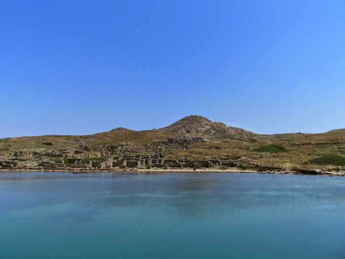
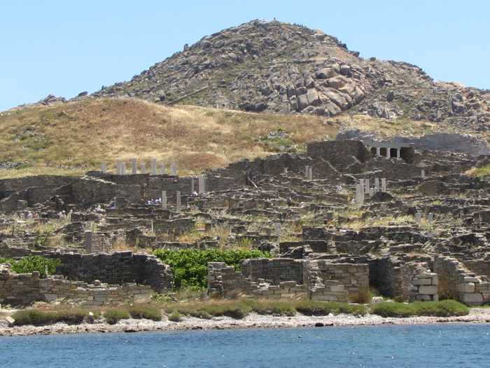
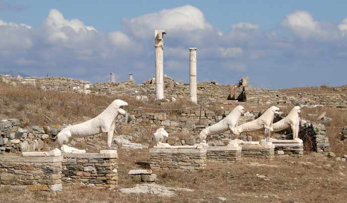
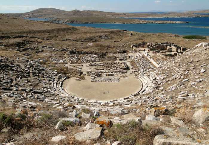
Each year, in fact, tens of thousands of people make the short half-day trip from Mykonos to Delos, an uninhabited isle which is one of the most significant historic and archaeological sites in all of Greece. (See my recent post Visiting Delos in 2016 for information about the many different ways to get there.)

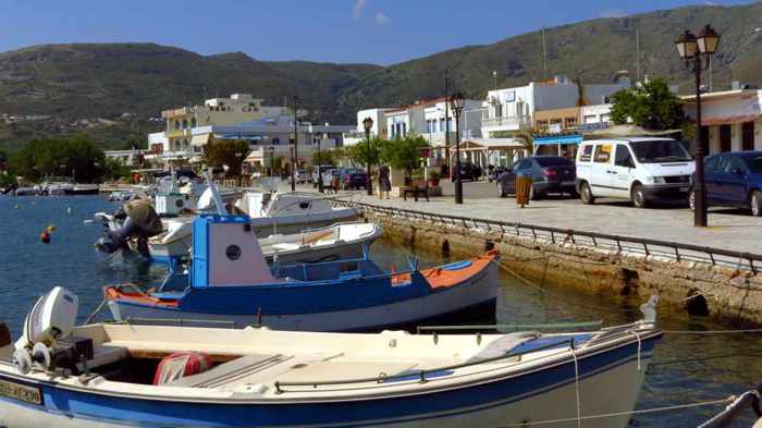
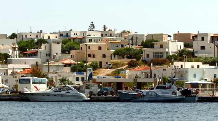
The next easiest getaway for a day is to Tinos, which can be reached either by regular ferry service from Mykonos, or on tours organized by excursion companies. Unlike hip Mykonos, which is one of the most contemporary and “touristy” destinations in Greece, Tinos offers a more authentic Greek island atmosphere and visitor experience.

Tom DeBelfore photo of Tripotamos village on Tinos island

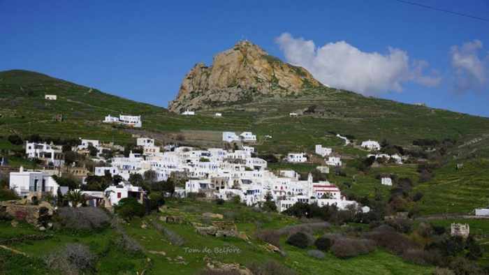
Tripotamos, one of 40 traditional villages on Tinos, is seen in a Tom DeBelfore photo from the Tinos, Kykladen/ Τήνος, Κυκλάδες page on Facebook. There’s nothing even remotely comparable to these villages on Mykonos.


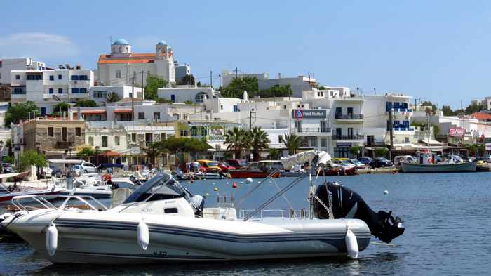
Mykonos is popular primarily for its beaches, its sophisticated hotels, bars, restaurants and nightlife, its picturesque Mykonos Town commercial center, and its legendary status as one of the leading holiday and party destinations for the international “jet set” since the 1960s.

Tinos has excellent beaches, bars and restaurants, too, but it also boasts sights and features you won’t find anywhere on Mykonos, including fabulous mountain scenery, dozens of traditional villages and settlements, thousands of dovecotes, and the Church of Panagia Evaggelistria, the country’s most-visited Greek Orthodox pilgrimage shrine.  An important center for religion with a long history of marble carving and stone artwork, Tinos gives visitors the opportunity to see a traditional side of Greece that’s almost impossible to find amidst the glitz and glamour of the designer boutiques, trendy nightclubs and posh resorts that abound on Mykonos.

Our Lady of Tinos church

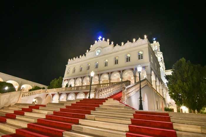
The Church of Panagia Evaggelistria (Our Lady of Tinos) is visited each year by thousands of tourists and Greek Orthodox pilgrims. This photo of the church appeared on the Facebook page for the local TINOS About magazine.


Because of their sharply contrasting attributes and attractions, the two islands might seem worlds apart. But since they’re separated by just a short ferry ride across a narrow channel, a daytrip to Tinos would nicely complement a longer stay on Mykonos (or vice versa).

So how can you get to Tinos? If you’re not comfortable arranging your own itinerary, drop into travel agencies or ferry ticket offices in Mykonos Town to inquire about times and prices for guided tours that might be available during your holiday. When you purchase tickets, make certain to ask where you catch your ferry — Mykonos has two ports! (The Old Port is right at Mykonos Town, while the New Port is located over 2 kilometers from town at Tourlos.)

If you would prefer to see Tinos independently, check with the Mykonos ferry ticket agencies for boat schedules on the particular day you’d like to do your daytrip. For years, the Theologos P car and passenger ferry has offered the most reliable and convenient round-trip ferry service between the two islands, with breakfast-time departures and mid-evening returns. Theologos P typically departs the Mykonos New Port around 7:35 a.m., arriving at Tinos Town 30 minutes later. You’ll be able to enjoy a full day of sightseeing and even dinner at a local taverna before sailing back to Mykonos on Theologos P’s 9:35 p.m. return voyage to Mykonos (it reaches the Mykonos New Port shortly past 10 p.m.).

Several other ferries operate between Mykonos and Tinos, but their later departures and earlier returns allow only a few hours on Tinos.  That’s still enough time to take a walk around Tinos Town and visit the island’s world-famous Our Lady of Tinos Church. But after getting to see Tinos for just three hours on our last vacation (see my previous post Our brief intro to Tinos for photos), we strongly recommend arranging as much time on the island as possible.

Friends who have done numerous daytrips say that by catching the Theologos P in the morning, they can take a taxi or bus to one of the mountain villages above Tinos Town, hike back down and spend a few hours sightseeing and having dinner in town. The return trip of Theologos P gets them back to Mykonos while the night is still young. Another possibility, they say, is to rent a car at Tinos Town and spend the day driving around to see some of the 40 villages, thousands of dovecotes and hundreds of chapels scattered across the island’s hills and mountainsides.

Dovecote on Tinos island

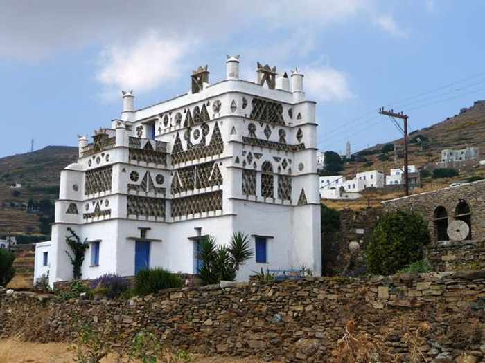
Thousands of impressive dovecotes can be spotted all over Tinos. This particular dovecote was renovated and converted into a private residence. (Photo from the tinos-tinos.com travel information website.)


If you want to get an idea of what Tinos is like (and also Mykonos, if you haven’t been there yet, either), watch the Hyperlapsing Tinos and Mykonos video that I posted at the top of this article. The 6.5-minute film will give you a speedy tour through the lanes and alleys of Tinos Town and Mykonos Town, and will take you to other parts of each island as well. It even shows some of the coastal scenery you’ll see on both islands during the ferry ride.

You can see more of Tinos in the video Tinos Greece 2015, below. It’s actually a slideshow presentation of photographs that YouTube contributor Lusko18 shot at numerous different locations on the island last year. 


This is a 5-minute slideshow of photographs shot by Lusko18 during a trip to Tinos in 2015

Glimpses of Gavrio, and a ferry ride from Andros to Tinos

Share

Gavrio port at Andros

Gavrio harbourfront

The harbourfront at Gavrio, the port village on Andros island


Au revoir, Andros: When we arrived at Gavrio port on Andros at the start of our Greek holiday last May, we barely even noticed the village. Already groggy from our transatlantic travel and jet lag, we were struggling to shake off more cobwebs after dozing periodically during the ferry ride from Rafina. 

I saw a few shops and tavernas when we stepped off the ship, and can even remember thinking “there doesn’t seem to be much here” when I took a quick glance around. We didn’t have time for a longer look since we had to focus our attention on a more pressing issue — fitting luggage for four people into the compact car our friends had rented.

Soon we were pulling away from the port and driving up a narrow lane that squeezed tightly between rows of whitewashed houses before widening into the two-lane highway that would lead us to Andros Town. As we rounded a bend on the outskirts of Gavrio, we got our first views of exhilarating Andros scenery — fields, beaches and the wide open sea on our right side, and to our left a long line of mountains extending far into the distance.  It was a beautiful sight for our sore and very tired eyes.

View from highway on outskirts of Gavrio Andros

The mountain and sea view from the outskirts of Gavrio, seen in an image from Google Street View. This is the highway that leads from Gavrio to Batsi and onward to Andros Town.


We got a better look at Gavrio when we walked there from Batsi on the final full day of our Andros visit. As we turned onto the waterfront strip, we discovered there was much more to the town than we had seen while disembarking the ferry five days earlier.

On arrival day, we had basically seen just half of Gavrio’s commercial district — the extensive port authority area with its parking lots, loading zones, and of course the quays for ferries and ships, as well as a few of the businesses along the main street nearby.  We had not noticed that the street continued farther past the port, lined on one side with tavernas, shops and ferry ticket agencies, and a flagstone-paved walkway on the sea side. It took longer than we had anticipated to stroll the entire length of the road, and we were surprised by the large selection of restaurants and cafes — we had not been expecting to be so spoiled for choice in finding a place to have lunch. 

Though not as scenic as some other port towns in the Cyclades, Gavrio isn’t an unattractive place — it just doesn’t have the pretty, polished veneer of upscale boutiques and trendy cafe-bars that draw  the big-spending tourist and cruise ship crowds to places like Mykonos Town. And while Gavrio may be conveniently located for quick easy access to a variety of good beaches (see my post A bevy of beaches & coves on the scenic west coast of Andros), we were happy we had chosen to spend our holiday time at Andros Town and Batsi instead, since we preferred their overall look and feel.

Mind you, we didn’t walk around any of the residential streets on the hills tucked behind the waterfront strip, so we didn’t get to see all of Gavrio. We may have been more impressed had we taken time to explore beyond the port and harbourfront.

Gavrio harbourfront

We didn’t get to explore the residential streets on the hill behind the commercial waterfront strip


The next day we got more glimpses of Gavrio during a taxi ride to the port, followed by panoramic sea views of all of Gavrio Bay as we stood on the outdoor decks of the ferry taking us to Tinos. It was a brilliantly sunny morning, and Gavrio looked picturesque as it glistened in the sunshine.  I’m sure we’ll be back sometime for another look around.

Click on the link below to see more photos of Gavrio, as well as pictures of the Andros coast that we passed during our ferry trip to Tinos. There also are photos of the ship that took us there, the Superferry II, as well as the western coast of Tinos.

CONTINUED ON PAGE 2

Considering Corfu for your next holiday? These videos may convince you to go

Share

Take a 3-minute aerial cruise above Corfu in this newly-released video, produced on behalf of the island’s port authority


Video vacation: I feel like I have just taken an extensive and exhausting (but in a good way) sightseeing trip to Corfu — even though I haven’t been there yet. And courtesy of several online videos I’ve been watching the past couple of days, it’s entirely possible that I may have just seen more of the island from here at home than I might have been able to see had I actually been on Corfu for the same period of time.

On March 14, a link to Corfu, the Garden of Gods (above) popped up in my social media news feeds, and I watched the film a few times.  The three-minute aerial video was shared by Vangelis Koulouris,  who said the short clip “was created for the Port Authority of Corfu with a view to highlight the unique environment and the multicultural history of Corfu island.”

The film features soaring views of Corfu’s lush landscapes, its picturesque coastlines and beaches, the island’s beautiful capital (also called Corfu), and cruise ships calling at its port. Corfu is, of course, one of the top Greek island destinations for cruise ships, so a video by its port authority just wouldn’t seem complete without at least a few passenger liners appearing in the picture.

As tends to happen whenever I find something interesting on social media, one thing led to another — and before long I had compiled a playlist of several more Corfu videos to view.  But except for Garden of the Gods, and another 3-minute clip, the other films weren’t as short and sweet — with run times ranging from 10 and 24 minutes to nearly two hours, they were the equivalent of watching a few evenings of TV programs. But I considered it “time well wasted,” as the saying goes.

It’s time some of you might wish to spend, too, should you be considering Corfu for an upcoming or future vacation — or should you simply want to see what the island is all about. To that end, I have posted some of the videos below. Four of the six films (including the one above) were  published just within the last several weeks, while two were released last year. What I appreciated most about the videos is that they either show or tell you the names of places you’re looking at — something all too many travel videos fail to do. 

If you manage to make it through all the clips, you’ll probably feel like you’ve just gone to the island, too — or attended a Corfu film festival!


My Corfu in 3 minutes is a quick-view highlight version of the considerably longer My Corfu, which is posted directly below.  Produced by Petros Kapsokavadis and the Oasis Hotel in Perama, it’s intended for viewers who don’t have enough time to watch the full-length clip.


This is the full 24-minute My Corfu video by Petros Kapsokavadis and the Oasis hotel. Most of the clip is aerial videography of places all around the island, but there is a segment showing part of the Corfu Mountain Trail footpath from Perama to Gastouri. 


Corfu — the island of eternal returns is a 10-minute film released just this month by the Mouzenidis Group of companies. A guide takes viewers on a tour of many of Corfu’s marvellous attractions, sights and scenery while describing highlights of the island’s history.


Corfu Coast Line is an aerial tour around the Corfu coast. The 48-minute film is a project of Corfu Benitses, the Association for Culture and Redevelopment of Benitses, a fishing village 12 km from Corfu city. 


The Corfu Vacation Travel Video Guide title says it all! Nearly 58 minutes long, the informative narrated film is a production of Exposa Travel.


My Movie Corfu Trail clocks in at 1 hour and 50 minutes but it is, after all, a video diary of a 10-day, 150-mile trek around the island that Tim Beal and a friend took last September.  “It is a fantastic walk and should be a tonic for all who like fine views, fine food and great people. Take two weeks out and walk Corfu… you will love it!” Tim says. If you don’t have the energy to attempt the walk yourself, simply sit back and watch Tim and his friend do it instead!

Video perspectives of Patmos island

Share

This is one of two aerial videos that the Municipality of Patmos released in early March to promote the charming isle, located in the Dodecanese chain of islands. The municipality’s other official film appears below.


Simply delightful: We have enjoyed every island we have visited in Greece, but some simply feel more comfortable, delightful and memorable than others. Patmos is one of them.

Although we have been to Patmos only once,  for four days in May 2010, it feels like it was just  yesterday — our memories of how the island looked and felt remain razor-sharp and almost palpable. 

Those feelings got tweaked a little last week when the Municipality of Patmos released two official videos to promote the island for 2016. The aerial film of the island’s beautiful sights and scenery included views of many places we saw six years ago, along with others we didn’t have enough time to visit. Surprisingly, the light and shadows in some of the video scenes looked the same as when we were there — particularly when the camera captures locations bathed in the golden glow of the setting sun.   

The clips include views of the island’s port town, Skala, the fortress-like Monastery of St John, Chora village, Grikos Bay, Kalikatsou Rock, and several of the island’s beautiful bays and beaches.

Watching the films has been a reminder that we’ve got to get back to Patmos to re-experience its charms and enchanting atmosphere. And to enjoy another serving (or two or three) of the absolutely amazing roasted chickpeas from Flisvos Taverna ….


« Older posts Newer posts »

© 2025

Theme by Anders NorenUp ↑